Vermont's Independent Voice
Browse News


Browse Arts + Culture


Browse Food + Drink


Browse Cannabis


Browse Music


Browse On Screen


Browse Events


Browse Classifieds
Browse Personals

Published November 9, 2012 at 10:56 a.m.
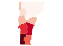
Maps are cool! Especially these maps created by Stone Environmental's Charlie Hofmann for the Vermont Secretary of State's elections web site.
Since they rely upon data from the state's voluntary election night reporting website, they are sadly incomplete for now. Town clerks reported the results from just 206 precincts that night — roughly 75 percent of the state's 275 precincts.
The secretary of state's office hopes to release unofficial results this weekend and certified results next Tuesday. We'll try to bring you complete maps when they're available.
Despite the missing info, these maps show some pretty interesting regional trends. The most obvious, of course, is the northbound retreat of the Vermont Republican Party. The GOP still has a couple southerly pockets of strength — particularly in Rutland County — but they are few and far between.
You can check out all the maps here. Also, in case it's not obvious, you can zoom in to view town names and check out a town's results by clicking on it.
President: This is both the most and least interesting map. Yeah, we all know President Obama beat Mitt Romney 67 to 31 percent in Vermont, but this map shows just one town going for Romney: Maidstone. (Of course, it's likely several other of the 69 precincts not included in the map also voted for Mittens.) Even in Maidstone, it was a close one. Romney won 52 votes to Obama's 50. If only the two voters who backed Gary Johnson and Rocky Anderson had backed Obama, it would've been a tie!
About The Author

Paul Heintz
Bio:
Paul Heintz was part of the Seven Days news team from 2012 to 2020. He served as political editor and wrote the "Fair Game" political column before becoming a staff writer.
Paul Heintz was part of the Seven Days news team from 2012 to 2020. He served as political editor and wrote the "Fair Game" political column before becoming a staff writer.
More By This Author


Latest in Off Message


Speaking of Interactive
-

Coronavirus Numbers in Vermont: A Seven Days Tracker
Mar 30, 2020 -
Data Dive: Vermont Has the Nation's Highest Lyme Disease Rate. Where Does Your County Rank?
Aug 2, 2019 -

Report Card: Studied to Death by the Vermont Legislature
May 31, 2017 -

The Media Bern: Sanders Keeps Vermont Press at Arm's Length
Mar 22, 2017 -

Coming and Going: Vermont Struggles to Grow Its Workforce
Feb 8, 2017 - More »

find, follow, fan us: