Published August 22, 2012 at 10:11 a.m.
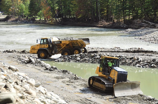
Earth mover photo by Jeb Wallace-Brodeur, all others by Paul Heintz.
Standing on a green iron bridge spanning the White River in Stockbridge, Greg Russ gestures upstream to a low-lying gravel bar carved out by the raging torrents of Tropical Storm Irene one year ago. The river here was ravaged by flood, but in certain stretches, he believes, the flooding improved it. “I know some of the people who live in the area think it’s ugly, it’s a scar, it’s a reminder,” Russ says. “But to me, I don’t think it looks bad. You know, this is kind of a floodplain now.”
Like a “major geologic reset button,” suggests the 40-year-old project manager of the White River Partnership, last year’s devastating flood left some sections of the White healthier than before. That mass of tree corpses and misshapen rocks upstream from the bridge? It will slow the river’s flow when the water rises next.
“Some people would see this and say, ‘See all this gravel in the river here? That should all get cleaned out,’” Russ continues. “But you want that channel roughness, because it displaces energy.”
Not every bend of the White River was left to recover naturally from the high waters of Irene. For weeks and months after the August 2011 storm, government contractors, municipalities and private citizens took to the river to access stranded towns, rebuild roads and — in some cases — take advantage of a temporary lawlessness to mine for gravel, wood and other natural resources.
According to one conservative estimate from Vermont Fish and Wildlife biologist Rich Kirn, at least 77 miles of southern and central Vermont rivers suffered “major degradation” as a result of ill-advised stream widening, straightening, mining and berming. Twenty-seven of those miles are right here on the White.
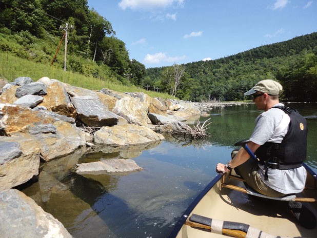
Below the green iron truss, Russ and I set out in a 16-foot Old Town canoe to see for ourselves how the White is faring a year after these twin disasters — one natural and one manmade.
On this sun-soaked August afternoon, the river is but a trickle compared with the deluge of last year’s flood. A gauge downstream in West Hartford measures the White at 3.5 feet today. When Irene struck, that same gauge showed the river cresting at 28.4 feet. Only in 1927 — when Vermont’s deadliest flood knocked out 30 buildings here, in what was then the bustling village of Gaysville — did the river rise higher, to 29.3 feet.
As we paddle along, scraping the green plastic canoe over rocks and navigating shallow rapids, we come upon sign after sign of human reengineering of the streambed. Beside one straightened channel lies a perfectly flat plane of rock and gravel, evidently evened out after an exercise in extraction.
“You can see it’s all compacted, kind of sculpted,” Russ says as we beach the canoe on river left. “They had the channel over on one side, taking gobs of material out.”
Like a barren moonscape, this leveled surface features few natural obstacles, such as boulders or plant matter, which might slow the river if it rose to this level. Gone are the enormous downed trees one can still see alongside many of Vermont’s hardest-hit rivers, with their trunks facing downstream and root structures mimicking the hair of a Maurice Sendak creature.
“It was virtual anarchy for a while,” Russ recalls as we walk along the river’s edge. “People just did what they wanted to do. When the state stopped widespread gravel extraction in the ’80s, a lot of people thought it was the wrong thing to do. So I think people just took the opportunity.”
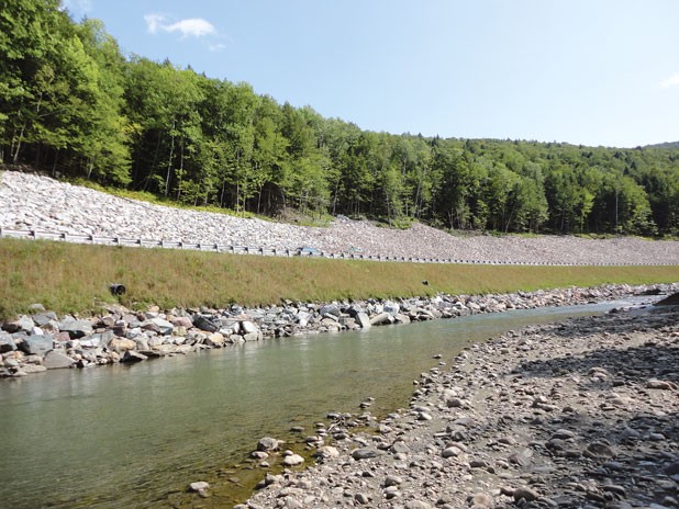
While some of the damage catalogued in Kirn’s river survey was surely inflicted by malevolent actors taking advantage of a breakdown in enforcement of environmental standards, other problems were caused by well-meaning road engineers employed by state and local governments. This becomes clear farther downstream when we come upon a newly riprapped bank supporting a rebuilt town road running just feet from the river. While these steep rock barriers may shore up public infrastructure, Russ says, they sharply deflect water, speeding up its flow.
“When you riprap something, you’re causing a problem downstream,” he notes.
In Russ’ view, what we are witnessing here is a kind of madness: the repetition of a destruction and rebuilding cycle in a narrow valley that cannot support both road and river.
“If you look at photos from the ’27 flood, it hit the same places. And it’s just going to keep on happening over and over again until we decide as a state — as taxpayers — that we don’t want to keep paying for the same stupid stuff over and over again. Should we have a road right next to the river?” he asks. “At a point, you’ve gotta say, ‘OK, how often are we going to keep rebuilding the same road or keep filling rock on the same problem?’ There’s gotta be a different way,” Russ concludes.
Fishing for understanding
In gauging the health of a river, says Clark Amadon, a Moretown resident who heads a chapter of Trout Unlimited, a conservation and sporting organization, one can learn a lot from the fish that reside in it. “Trout are really indicator species,” he says. “If you find a river that has cold-water trout in it, you’re generally going to find a river system that’s pretty healthy.”
Early counts of fish populations in Irene-damaged rivers paint a mixed picture.
“We’re finding that in areas that were damaged just by storm damage, trout populations are generally good — in some cases, very good,” says Kirn, the Vermont Fish and Wildlife biologist. “In areas where there was extensive removal of in-stream material and the stream is homogenous, there’s really only habitat for young fish.”
While Kirn expects trout populations to fully recover within a few years in places damaged solely by the storm, he says recovery in long stretches of human-damaged river may take decades.
“Floods are natural phenomena for rivers and the critters that live in rivers,” explains Rep. David Deen (D-Westminster), a river steward for the Connecticut River Watershed Council and chairman of the House Fish, Wildlife and Water Resources Committee. “They’re designed to deal with floods. It’s we humans that aren’t designed to deal with floods.”
Deen is hoping that in the wake of Irene, that will change. Like most people interviewed for this story, he was hesitant to ascribe blame to those who, in the storm’s aftermath, unintentionally degraded fish habitat and exacerbated the risk of flooding. River science, he says, has evolved rapidly in the past few decades, but public understanding has not kept pace.
“We’ve learned an awful lot lately. It’s a matter of getting that out to people who know how to run the big yellow machines, but don’t necessarily know anything about rivers,” Deen says. “Until science is understood, quote unquote ‘conventional wisdom’ prevails.”
He points to a new state law passed last spring that will, in part, provide new river-science training to heavy machinery operators. The law, Act 138, also clarifies the Agency of Natural Resources’ authority over stream alteration and calls for new emergency flood-response procedures. They’re meant to avoid what Louis Porter of the Conservation Law Foundation calls last fall’s “systemic breakdown at all levels.
“I think the manmade disaster was unfortunate, because so much of it was avoidable,” Porter says. “By some estimates, half or more of the work done in rivers was unnecessary and made flood risk greater, not less.”
With global climate change already bringing more heavy precipitation to the Northeast, Porter says, Vermont needs to get serious about preparing for future flooding and taking steps to prevent it.
“We are in for a lot more wet and violent weather,” he says. “We need to realize we’re going to need all of that flood capacity, all of that natural resilience in the years to come. And I don’t see that being understood to the extent it needs to be understood yet.”
A road and a river
Two miles south of the Gaysville bridge, Russ and I reach a bend in the White River that epitomizes the challenge faced by those charged with keeping roads running through narrow river valleys.
Here, the east-flowing river curves sharply to the north, shifting its course nearly 90 degrees in just 200 yards. Around the outside bend of the river runs Route 107, a critical east-west state highway that was rendered impassable by Irene.
Rebuilt now, 107 looms above a freshly channeled river, protected only by a narrow band of riprap and a few feet of elevation. As cars and trucks whip around the bend, it calls to mind the contours of a racetrack. One can easily picture the roaring waters of a future flood speeding around the corner and over these banks, the way every major flood before it has.
“In my opinion, there’s just no room for the river,” Russ says as we float down the winding channel. “You’re always going to fight the river here.”
Russ says he once heard a line that’s stuck with him ever since: “Building a house or putting infrastructure in a floodplain is like pitching a tent on the interstate when there are no cars coming.” Only in this case, despite the tent getting run over repeatedly, its occupants keep heading back to the store to buy another one.
Rep. Deen believes that continually rebuilding Route 107 is a fool’s errand. He says the federal government needs to provide more disaster-mitigation funding to move the road out of harm’s way.
“It would be expensive,” he says, “but what if we have to go back and replace Route 107 again? Because the river’s gonna do the same damn thing it did last time.”
To Kevin Marshia, a highway safety and design engineer for the Vermont Agency of Transportation, that approach is simply not an option.
“To move that road, you’re looking at an additional whole host of potential environmental impacts and, frankly, an extremely high cost,” Marshia says. “Really, where our focus is is reconnecting those areas and doing everything we can to strengthen that infrastructure.”
Working with river scientists from ANR, Marshia’s agency recently reviewed 682 sites where it performed emergency work immediately after Irene and found that nearly half of them — 323 sites — require additional work. Thirty percent of those problem areas require more channel work, including the removal of berming and other river constrictions, and another 20 percent involve improving culverts and ditching.
Now that the immediate crisis has passed, Marshia says VTrans is committed to revisiting areas where emergency work may have damaged the rivers.
“We were dealing with up to 15 isolated communities, completely cut off. The mission was life, safety, health,” he says. “In some of those areas, we did what we had to do to make sure folks were safe. In some of those instances, we do recognize some of the initial response may have created issues we’re going back to address.
“We were then — and we are now — committed to doing the right thing,” Marshia adds.
Waiting for a flood
In Bethel now, Russ and I paddle onward past the White River National Fish Hatchery, which was shuttered by Irene but which federal officials hope to reopen someday. In this section of river, we come upon deep pools scoured by the storm and healthy banks covered by downed trees: ideal trout habitat.
Russ has worked with the White River Partnership since 2001 — first as a volunteer, since 2009 as an employee. He seems to know this river like the back of his hand. But it’s his first time paddling this section since the storm, and he marvels at each of the changes.
In his view, it’s not all bad. As often as he shakes his head at an excavation site or an encroaching roadway, Russ smiles at a new fishing hole or a deep pool perfect for swimming.
“I think the river looks pretty good,” he says as we float past a cornfield near where Cleveland Brook enters the river. “It looks pretty good from the river level.”
Pointing upstream to an S curve we’ve just rounded, Russ explains that the river here used to braid around both sides of an island. Sediment carried downstream by Irene filled in one of the channels, though, creating a new floodplain that Russ hopes will fill with healthy debris.
Like many river watchers, he’s waiting anxiously for the next high water. A mild ice-out and a dry summer have kept smaller floods from performing restorative work to the White River — washing organic material downstream, providing new cover habitat and pushing aside the work of men.
Mike Kline, manager of the Agency of Natural Resources’ rivers program, calls it “rearranging the furniture,” and he can’t wait.
“The big thing that’s going to help us see our rivers get back to better health is, believe it or not, more high flows,” he says.
While Kline and his staff are working with towns to right-size culverts and improve road banks, they are waiting to see what the river does on its own before making too many more changes to the riverbed.
“It’s my feeling as a river ecologist that we need to get some floods down these systems before we try to guess where habitat is going to spring up,” he says.
As Russ puts it, “It’s just gonna take time for things to sort themselves out. The river’s always adjusting, always changing.”
As we reach our destination at Bethel’s riverside Peavine Park, the stakes of Kline’s work are abundantly clear. Directly ahead of us, where the Third Branch of the White River meets the main stem on which we’ve been paddling, the combined flow cuts a sharp, 180-degree turn to the south. Sitting astride the bend is the village of Bethel, helplessly waiting for the next flood to jump the river’s banks.
The town’s fate is in the hands of nature, but it is also in the hands of man. How the river is managed upstream of this bend will govern the velocity at which the next floodwaters arrive. While we cannot stop the river, we can surely slow it down.

In Stockbridge, Greg Russ assesses the White River's recovery. Photo by Paul Heintz.
More By This Author
Speaking of...
-

Gov. Scott, Federal Officials Tour Vermont Flood Damage
Jul 12, 2023 -

Heavy Rain, Flooding Hits Vermont — and Rivers Are Rising
Jul 10, 2023 -

Regulators Are Poised to Let Vermont Gas Buy Methane From a Distant Landfill
Oct 21, 2022 -

Richmond Vows to Return to 'Full Fluoride' Levels
Oct 3, 2022 -

Richmond Learns a Town Official Lowered the Fluoride Level in Its Water for Years
Sep 28, 2022 - More »
Comments
Comments are closed.
From 2014-2020, Seven Days allowed readers to comment on all stories posted on our website. While we've appreciated the suggestions and insights, right now Seven Days is prioritizing our core mission — producing high-quality, responsible local journalism — over moderating online debates between readers.
To criticize, correct or praise our reporting, please send us a letter to the editor or send us a tip. We’ll check it out and report the results.
Online comments may return when we have better tech tools for managing them. Thanks for reading.


