Vermont's Independent Voice
Browse News


Browse Arts + Culture


Browse Food + Drink


Browse Cannabis


Browse Music


Browse On Screen

Browse Events


Browse Classifieds
Browse Personals

Published July 19, 2006 at 2:54 p.m.
Vermont is the right place to be if you're a nature lover. The state still claims pristine waterways and scenic mountain vistas unspoiled by visible traces of habitation. But if avoiding humans is what you're after, you're probably not interested in spending a day on the Winooski River. It meanders through the most densely populated part of the state, its flow interrupted by dams, its waters muddied by pollution, its banks eroded by farmland and housing developments, its calm shattered by trains, planes and automobiles. The river's history is inexorably entwined with the human history of northwestern and central Vermont.
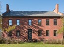
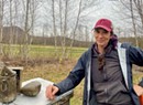
And that's what Charles Fish loves about it. The aptly named retired English professor grew up in Essex Junction. He fished the river as a boy, and hunted on its banks. Fish left the area shortly after graduating from Essex High School in 1954 - he received his PhD at Princeton University, and has lived since 1968 in Dummerston - but the Winooski remains close to his heart.
Now he's turned his lifelong fascination into a book, In the Land of the Wild Onion: Travels Along Vermont's Winooski River, published last month by the University of Vermont Press in conjunction with the University Press of New England.
Fish spent nearly a decade augmenting his boyhood memories with knowledge gleaned from the people he met while traveling the river on foot and by canoe. The result is a thorough and engaging narrative that examines the entire watershed from geological, economic, historical and personal perspectives. It's a whole new way of looking at the Winooski, which many Vermonters barely notice as they speed past it on I-89.
Fish acknowledges that apathy. "You can drive over this river 365 days a year," he says, "and you just don't pay attention." He hopes to spark some interest in the Winooski with his book, and gleefully agrees to spend a Saturday in July giving me a guided tour of some of his favorite spots.
"I want people to understand how we take care of and live in the watershed," he explains. "I want people to be thoughtful about where they live."
********
We meet at Overlook Park on Route 2A in Williston, across the river from Essex Junction. We plan to canoe a stretch of river downstream from the Essex power plant, but first we're headed east. At 8:45 a.m., we set out for Montpelier in Fish's silver Buick, leaving the canoe strapped to my car.
On the way to the state capital, Fish offers some background data. Extending 90 miles, the Winooski is not Vermont's longest river; that honor belongs to the 100-mile Otter Creek. But the Winooski's watershed - the surface area that collects water for the river - is the largest in Vermont, New York and Quebec, covering 1080 square miles. That's 11 percent of the state.
As we travel I-89 through the valley in Richmond, Fish explains that the river has been part of this landscape for a long, long time. It's an antecedent river, which means that it predates the upheaval of the Earth's crust that made the mountains. Geologists, he says, are still investigating its origins.
The Winooski valley was once covered by glaciers 1 to 2 miles thick. They retreated 10,000 years ago, but not before carving up the landscape. In Bolton Flats, the car swerves slightly as Fish points to several rounded hills with steep cliffs called roches moutonees, or "sheep rocks."
"The glacier came in, froze into the rock face, and broke off," he says, "carrying chunks of the mountain." The most notable example of this process is the angular peak of Camel's Hump. The glaciers later deposited the stones they stole all along the valley. Throughout the day Fish points out random boulders called "glacial erratics."
In Montpelier, we drive to the spot where Fish came closest to being killed during his travels. It's actually not on the river itself but along a stretch of Route 2.
Fish canoed the entire river twice in the late 1990s, once doing only sections at a time, using his car to portage the boat. The second time he floated from Marshfield to Burlington, portaging his 12-foot, 58-pound fiberglass canoe mostly on foot. He camped on the banks along the way.
Slight but spry, Fish completed the trek in five days, quite a feat for a guy in his sixties. The indefatigable scholar, who retired from Western New England College in 2001 and still teaches as an adjunct professor at Boston College, turns 70 on July 27.
It was during Fish's second trip that he was nearly run over. He pulled his canoe from the water before a small dam in Montpelier. He fastened the boat to a wheeled carrier and dragged it along Route 2 during rush hour. Cars whizzed by at 50 miles an hour. That, Fish says, was the scariest part of any of his trips.
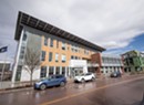
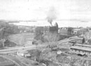
Our next stop is also urban; Fish takes me to the Montpelier Sewage Treatment Plant, which releases an average of 2 million gallons of water into the river each day. Treatment plants comprise one of the major reasons the Winooski is cleaner now than it was when Fish was growing up. Until 1964, all sewage ran directly into the river. The Winooski was literally an open sewer.
The river is now lined with treatment facilities; Fish chose to highlight this one in his book because of its reputation for good management practices.
At the plant, we meet Assistant Chief Operator Robert Fischer. He tells us the water coming from his plant has been scrubbed mostly clean of pollutants such as E. coli bacteria and phosphorus, which causes algae blooms in Lake Champlain. It's technically not potable, but Fischer says the water is essentially 97 or 98 percent clean. "I would certainly drink the water coming out of the plant before I'd drink the water in the river," he says.
We follow Fischer as he takes water samples. He fills one bucket from a pipe labeled "effluent" at the back of the building, then takes us outside to a concrete slab. He opens a metal door and lowers a gray plastic bucket on a rope into a stream of sewage that passes about 10 feet below. He brings the samples into the plant's lab, dons latex gloves, and pours the buckets' contents into two glass beakers. The plant's discharge is clear, while the sewage from the area's toilets and sink drains predictably cloudy.
Fischer sometimes finds things floating in the stream. No poop, he says -- "it dissolves pretty quickly." Usually he sees toys, tampons and condoms.
The plant can't remove everything. The charts on the walls show dramatically reduced levels of pollutants, but some stuff still gets through, especially when the river is swollen from heavy rains.
Both Fischer and Fish say most pollution these days comes from "non-point sources," such as agricultural run-off and chemicals from lawns and roadways. Though treatment plants handle the septic and industrial load, federal guidelines mandate that the grates you see along the roads drain unfiltered into the river. That non-point pollution makes swimming in the Winooski inadvisable. Fischer has never been. A former fish biologist for the U.S. Forest Service, he says he's gotten sick too many times in cleaner streams out West to risk it.
********
Our next two stops take us back to nature. Fish drives north on I-89 to Middlesex. He pulls over on Route 100B to show me the steep trail he climbed while portaging his canoe. We walk through a patch of knee-high daisies, vetch, burdock and Queen Anne's Lace to peer through a fence at the gorge below. Fish notes the vertical striations on the opposing rock face, layers of minerals compressed by unimaginable force. In the book, he refers to the sight as "geologic poetry."
From there we take Route 2 as it winds along the river through Waterbury, past the old Vemront Hospital and the state office complex. We turn left on Winooski Street, cross the river, and turn right on River Road. This runs roughly parallel to the river, and to Route 2, I-89 and a series of railroad tracks. The valley is a heavily trafficked transportation corridor, inaugurated years before by the river itself, which was used by the Abenaki. As we drive along River Road, the muddy-brown Winooski is often visible through the trees to our right.
It's hard to imagine that this lazy water could be deadly, but Fish reminds me that during the 1927 flood, the narrow stretch just ahead in Bolton killed more people than any other part of the river. The flood killed 55 people in the Winooski Valley, 26 of them in Bolton.
The river took a life not far from here just this spring, when a St. Michael's College senior died canoeing after heavy rains. "We don't ever really tame a river," Fish solemnly observes.
He soon turns right over a one-lane bridge that crosses the railroad tracks. It leads to the DeForge Hydroelectric Station, also known as Bolton Dam. We leave the car and climb a steep path through swarms of biting insects to a point that surveys the Bolton Gorge, the state's second largest. We pass towering, high-voltage electrical lines belonging to Green Mountain Power. The company owns the land and the dam. At the top of the ridge, the vista includes rocky cliffs, the dam and a seemingly placid pool in the river more than 100 feet below. Camel's Hump rises in the distance. "Isn't this grand?" Fish murmurs.
He notes that to our left is Allen's Rock. More than 200 years ago, Ira Allen is said to have ventured here with a small party of friends. They dared each other to step close to the void and look down. Allen supposedly stepped closest to the edge, giving the point its name.
Fish also walked out on the point while researching his book and, knees knocking, contemplated the drop. It seems a popular pursuit, judging from the cigarette butts scattered nearby.
In his book, Fish calls the view "sublime." "The word has lost much of its force in common parlance," he writes in the chapter titled "From Gorge to Gorge." "More than simply supreme or excellent, it suggested an awe-inspiring majesty, and unlike the beautiful, to which it was often contrasted, it could evoke feelings of terror as the merely human confronted grandeur and power on a supra-human scale."
As we admire the lush scenery, Fish recalls the trip during which he made that observation. "As I was sitting here meditating on the sublime, a train came by," he says with a chuckle. "There's always something to remind you that this is a human valley."
A nearer reminder is I-89, which runs close by on the opposite side of the gorge. You can see the cars flickering past through the trees, and the traffic noise is unmistakable. In the winter, Fish says, you can glimpse Allen's Rock from the highway. Otherwise, the garish orange markers on the power lines above are the only indication that you're driving past this scenic spot.
The site is more than a transportation corridor with a colorful anecdote and a good view. Fish points to the dam below; hydropower produces less than 5 percent of Green Mountain Power's electricity, but it's still crucial. When proponents of hydroelectric energy look at this stretch of river, he says, "They see it, of course, as a source of power, a system of energy."
From Bolton, we head to Richmond, passing Volunteers Green, where pint-sized athletes play a Little League All-Star game. When the Winooski floods, as it did this spring, their field becomes part of the river.
At the outskirts of town, the valley widens, revealing a swath of farmland. A small cluster of Holsteins grazes a few hundred feet from the road. Fish remarks, "That's an increasingly rare sight."
His comment is underscored at our next stop, the Whitcomb Farm in North Williston, which abuts the river. The Whitcombs, who own one of Chittenden County's few surviving dairy farms, confine their herd to pens in two large, rounded-roof barns. They feed the animals with grain grown in their fields, which they spray with pesticides. This is properly called conventional agriculture, but the Whitcombs are also innovating. Their farm recently served as a test site for an anaerobic digester, which turns the methane from cow manure into energy.
Fish knew Ed Whitcomb years ago, and spoke to him as he began research on the book, but Whitcomb was killed in a farming accident shortly after they reconnected.
Death is a pervasive presence in Fish's stories. Near the Whitcomb Farm is the railroad trestle where four of Fish's high school classmates were killed in December 1953. We drive past it on our way to Essex Junction. "They were racing a train, and they tied," he remembers. "We heard the ambulance go by our house."
Today there's no sign that an accident ever happened at this sleepy crossing, and there's little evidence of the commercial district that Fish says once existed here. Towns die, too.
The cold storage plant, built in 1876, burned down in the early 1900s. Gone as well are the sawmill, gristmill, post office and creamery. Their disappearance might have something to do with the Dust Bowl-like conditions that arose because of severe deforestation in the 1920s. Intensive planting efforts by the University of Vermont and the National Resource Conservation Service brought back the trees along the river, but the railroad village is gone for good.
********
It's nearly one o'clock when we drive through Essex Junction. Fish points to landmarks -- his childhood home on the corner of Maple and East Streets, the house where the wily "Bobcat Man" of his book lives, the location of the ice house where Fish's family would go to stock their icebox. We unload the canoe, park my car on a road across from the Burlington International Airport, and return to Williston in Fish's car to carry the canoe to the water.
We put in just below the Essex Dam. Before we do, Fish tells me the story of Dale Bacon, who fell 65 feet while replacing the wooden flashboards that used to lie across the top of the dam. In addition to various other serious injuries, "He dislocated all of his fingers trying to hold onto the concrete," Fish marvels.
Once in the water, we enter some mild rapids. We're in a slightly larger canoe than the one Fish used last time, but with the addition of a photographer we're three in the boat. We ride so low that we're nearly swamped. Everything and everyone on board gets soaked.
After we're clear, Fish confesses, "The closest I ever came to capsizing on the Winooski was in that stretch back there."
The calm water that follows offers a chance to reflect. Dense vegetation lines the banks. Not even Fish can tell exactly where we are at any given moment. It's amazing how remote the river seems, though people and commerce, and the ever-present sound of traffic, surround us on all sides.
Fish occasionally notes erosion on the banks. We see whole trunks of still-green trees about to slide topsy-turvy into the current. The biggest danger to the river -- apart from events like the ammonia spill at the Cabot Creamery last year -- is actually sediment. It destroys wildlife habitat.
And critters still abound; we see a blue heron, several ducks, a flock of geese and two turkey vultures, one of them circling above an unidentifiable, fly-infested carcass we find on a small, sandy island. A log in front of us in the water turns out to be the head of some furry creature; it dives as we approach.
Even more delightful is the trip beneath the Lime Kiln bridge. The construction site above is ugly, but the view of the limestone cliffs from below is breathtaking. The large, rounded hollows that loom above us in the rock resemble something out of Lord of the Rings. We see initials carved into the wall in elegant script beside a year: 1862. "This is one of my favorite places along the river," Fish intones reverently.
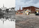
Back on land, we lift the canoe onto my car, and proceed to Salmon Hole in Winooski. Fish devotes a whole chapter to the former mill town, and another to the Abenaki Indians who once gathered here below the falls, and who gave the river its name; it means "wild onion."
We walk along a paved path next to the old Woolen Mill. "Many years ago, when the mills were running, this was a crummy area," Fish recalls. "Now it's a park." Sure enough, three teenagers are walking on one of the small islands below us, a lone kayaker shoots the rapids, and several people are strolling on the new Winooski Riverwalk nearby.
But this nook still has its seedy side. Two young girls peer over the metal railing to look at the trash accumulating in the brownish foam next to the dam. "There's, like, an Adidas flip-flop, a regular flip-flop, spray paint, tires -- everything's in there," one of them says.
But the trash isn't visible from the rocks overlooking Salmon Hole beneath the dam. A slight mist hangs in the late afternoon air, and as you view the famed prehistoric cove, you can almost imagine what it must have looked like hundreds of years ago. "Historically, geologically, scenically -- what a sight!" enthuses Fish. "It's a feast for the eyes."
********
Finally, we drive to our last stop, the basin where the Winooski empties into Lake Champlain. We park near the Bike Path and walk to the bridge that connects it to Colchester. To our left is the Mouth of the River neighborhood, also called the North Avenue Extension, where Fish's friend Azarius Beaudoin grew up trapping muskrats, minks and beavers. A light rain has begun to fall, driving away most of the early evening traffic. But it hasn't deterred three young boys and a girl who are jumping from the bridge into the water 15 or 20 feet below.
Fish watches the teens enviously. "That's terrific," he says. "That's what it ought to be like when you're a kid."
I explain to one of the boys that Fish and I have spent the day exploring the river, that the waterway has great geological, environmental and historical significance. Is he thinking about any of that when he plummets into it? "Not really," he says with a shrug.
Fish is too moved by the kids' exuberance as they hurl themselves into the water to be bothered by the answer. He admits that teaching people about the watershed was only part of his motivation for writing the book. "It's also about wanting someone else to share my enthusiasm for the river," he explains.
The skinny, wet kids, laughing and teasing each other as they scramble up the bank, surely do.
More By This Author


About The Author

Cathy Resmer
Bio:
Deputy publisher Cathy Resmer is an organizer of the Vermont Tech Jam. She also oversees Seven Days' parenting publication, Kids VT, and created the Good Citizen Challenge, a youth civics initiative. Resmer began her career at Seven Days as a freelance writer in 2001. Hired as a staff writer in 2005, she became the publication's first online editor in 2007.
Deputy publisher Cathy Resmer is an organizer of the Vermont Tech Jam. She also oversees Seven Days' parenting publication, Kids VT, and created the Good Citizen Challenge, a youth civics initiative. Resmer began her career at Seven Days as a freelance writer in 2001. Hired as a staff writer in 2005, she became the publication's first online editor in 2007.
Speaking of...
-
Q&A: Catching Up With the Champlain Valley Quilt Guild
Apr 10, 2024 -

Video: The Champlain Valley Quilt Guild Prepares for Its Biennial Quilt Show
Apr 4, 2024 -
Q&A: Digging Into the Remnants of the Ravine That Divided Burlington
Mar 27, 2024 -
Video: Digging Into the Ravine That Divided Burlington in the 1800s
Mar 21, 2024 -

Q&A: Repairing a Historic Smokestack From a Floating Basket
Nov 22, 2023 - More »
Comments
Comments are closed.
From 2014-2020, Seven Days allowed readers to comment on all stories posted on our website. While we've appreciated the suggestions and insights, right now Seven Days is prioritizing our core mission — producing high-quality, responsible local journalism — over moderating online debates between readers.
To criticize, correct or praise our reporting, please send us a letter to the editor or send us a tip. We’ll check it out and report the results.
Online comments may return when we have better tech tools for managing them. Thanks for reading.