Vermont's Independent Voice
Browse News


Browse Arts + Culture


Browse Food + Drink


Browse Cannabis


Browse Music


Browse On Screen


Browse Events


Browse Classifieds
Browse Personals

Published June 8, 2022 at 10:00 a.m. | Updated June 21, 2022 at 2:27 p.m.

Vermont is the fourth most forested state in the country, with three-quarters of it covered in woods. Nearly 80 percent of its forests — an estimated 3.5 million acres — are owned not by the state or federal government but by private landowners. The majority of those holdings — about 2.7 million acres — belong to local families, according to the U.S. Department of Agriculture's Forest Service.
Visit any of Vermont's most popular recreational spots — Camel's Hump, Mount Mansfield, Mount Pisgah — and you'll invariably tread on some private land. Ride on the more than 100 miles of mountain bike trails managed by the Kingdom Trails Association, or the more than 5,000 miles of snowmobile trails maintained by the Vermont Association of Snow Travelers, and you'll cross a patchwork of private property made accessible by thousands of Vermont families.
In short, the Green Mountain State remains green because Vermonters want to keep it that way — for themselves and their neighbors. In a March 2020 survey of Vermont landowners conducted by the forest service, they cited aesthetics, protection of wildlife, privacy and access to nature as top reasons for keeping their woods wild. Personal financial gain, including investment, timber harvest and tax benefits, was not a major motivator.
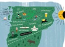
In this story, Seven Days highlights seven hikes on private property and the landowners who generously allow the public to use them. We chose these locations for their diversity in geography and size — they range from 35 to 4,000 acres. Some, like Tracy Woods in South Hero, offer well-worn trails that have been used for decades. Others, like Black Hills in Glover, have newly built trails.
Vermont's tradition of open access to private land is as old as the state itself. Vermonters have long abided by a land-use ethos that, unless otherwise posted, welcomes visitors, provided that they respect the land and cause no damage.
Because of this informal arrangement, Vermont was among the last states in the U.S. to adopt a recreational use statute. The 1998 law limits landowners' liability for property damage or personal injury to people who visit their land unless either results from the "willful or wanton misconduct of the owner."
But limiting liability, by itself, doesn't ensure that private lands will forever remain accessible. Unlike state parks and national forests, landowners can quickly close their gates to the public if users don't respect the land or its owners.
In 2019 three landowners pulled their property out of the Kingdom Trails network due to ongoing conflicts between mountain bikers and landowners, as the New York Times noted in a May 23 story titled, "In Northern Vermont, Trying to Smooth the Ride for Mountain Biking."
Other landowners are wary of publicity. A number of those contacted for this story declined to allow Seven Days to feature their properties, citing ongoing concerns about parking, overuse, trail damage and less-than-neighborly behavior by some visitors.
"This is a reciprocal relationship," said Abby White, vice president for engagement for the Vermont Land Trust, which has conserved more than 620,000 acres across the state through land purchases, donor bequests and conservation easements. "It requires some give-and-take on everyone's part."
In addition to the Vermont Land Trust, many state and local land trusts help property owners conserve and manage their land for public and private use. Six entities make their private land available as part of the 19-mile network of trails that encircles the town of Middlebury, for example, overseen and expertly maintained by the Middlebury Area Land Trust. Seven Days publisher Paula Routly spent the better part of a morning exploring a section of it.
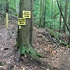
Some of the trails featured below aren't so well marked; others have no signage at all. Whenever possible, hikers should verify in advance the location of trailheads and parking areas, and they should always abide by posted no-trespassing signs.
I learned that lesson the hard way. During one outing for this story, I had the landowner's permission, but inaccurate directions, to visit the property. Inadvertently, I crossed a gate onto someone else's private land. Hours later, when I returned to my car, I heard a gunshot whiz through the trees.
The message behind the warning shot was clear: Not all Vermonters welcome uninvited visitors.
— K.P.
'My Church'

Forest land in Glover and Greensboro owned by Black Hills Timber. Public access at 282 Black Hills Drive, Greensboro. About 13 miles of trails are easy to strenuous depending on distance and route.
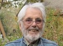
When foresters walk through woods, they look down, not up. What's growing at ground level tells them a lot about the health of the woodland, said Richard "Carbo" Carbonetti, an Albany-based forester with 44 years of experience.
Scouting a 1,700-acre parcel of Glover woods more than a quarter century ago, Carbonetti saw stinging nettle, ramps, maidenhair fern, and red and blue cohosh. The plants were indicative of nutrient-rich soil and a healthy and productive northern hardwood forest. It means "Mother Nature has given you a wonderful palette to work with," Carbonetti said.
The land impressed and excited him. Little did he know that one day he'd be in a position to open it to the public.
Carbonetti is a partner at LandVest, a Boston-based company that manages 2.5 million acres of timberland from northern Maine to Virginia. His botanical reconnaissance that day in 1994 was on behalf of a Canadian client named Robert Louis Irwin, a onetime professor of organic chemistry at Goddard College. Irwin purchased the Glover timberland, property that would become part of Irwin's Vermont forest holdings of roughly 5,400 acres.
When Irwin died in 2009, at 89, Carbonetti was one of three people named in his will, the forester said. The estate was settled in 2013, and Carbonetti became owner of 1,927 acres of timberland in Orleans County. The majority is in Glover, with 189 contiguous acres in Greensboro.
"I call this my church," Carbonetti, 67, said on a recent afternoon in the woods, looking at the leafy tops of rod-straight, century-old maples. "I took this very personally as a sacred trust."
At roughly three square miles, the woodland is the largest piece of private property in Glover. Under Carbonetti's ownership, it's open to the public; a conservation easement with the Vermont Land Trust ensures that the land will never be developed or subdivided. The agreement allows for one cabin, which Carbonetti is building on 10 acres he's keeping private. People are welcome to walk — but not bike — on all but that piece, except during hunting season. For safety reasons, from the beginning of September until the end of December, he limits access to members of the Black Hills Hunt Club.
The key to the timberland's health and resilience is the careful and patient method by which it's been managed for the last half century, Carbonetti explained. Forestry, he noted, is a "long-term enterprise."
"You manage the forest carefully and extract a judicious amount of value over time," he said. "We're growing more trees than we're cutting."
Orleans County forester Jared Nunery oversees the forest management plan for the property. A significant and beneficial feature of the woodland is that it's part of a large tract of contiguous, conserved land, he said. It's adjacent to Vermont Land Trust and Nature Conservancy properties, comprising a total of roughly 3,000 acres of forest.
In managing land, a forester doesn't need trails, Carbonetti said. "That's not what we're about."
But he likes trails. And he wants his Glover property not only to be accessible to the public but also enjoyable. So he's clearing and marking 18 miles of trails, routes he has mapped out in his head. Some follow old lumber roads; others are narrow pathways past stands of maple, beech and yellow birch. An offshoot trail leads to Mud Pond — vast, lovely and still on a warm spring day. Another path runs past a spring-fed brook where trout dart in the water and hide under sticks.
Walking on a three-mile loop through the woods, which rise on his property to 2,300 feet at the top of Black Hills, Carbonetti noted moose tracks, beaver lodges and saplings where moose had fed. He observed a path cleared by wildlife that crosses one made by humans.
Carbonetti also pointed out a cellar hole on the Greensboro portion of the land — a relic of a home once inhabited by author Wallace Stegner. (See "A Family Tradition") The forester stopped at a granite marker that he had placed under a tall maple. The stone commemorates Irwin and honors the former owner's "vision and ethics" in caring for the woods.
Carbonetti plans to build a kiosk at the entrance to his property with a sign-in log, a map of the trails and a box for questions for the forester. His answers, which he plans to send via email, are likely to engender greater understanding of and appreciation for the land.
For any piece of land, Nunery noted, what's important is the landowner's connection to it. "We're here for a finite period of time," he said. "The land's here for longer."
— S.P.
A Family Tradition

Barr Hill Trail, Highland Lodge, 1608 Craftsbury Road, Greensboro. Roughly two miles of moderate trails.
In 1971, retired Scripps College English professor Philip Gray gave the Nature Conservancy a piece of hilltop land in Greensboro that presents a glorious view to the southwest and invites exploration of surrounding woods and nearby meadows. Gray donated the 256-acre Barr Hill Natural Area on behalf of himself and his late wife, Margaret "Peg" Day Gray.
"Our family was very attached to Barr Hill," said Clive Gray, 88, one of Philip and Peg's six children. "They wanted to keep it open for families to enjoy."
The Barr Hill Trail passes by cushiony moss, open fields, raspberry bushes, hardwoods, evergreens and wildflowers. It follows an old horse trail and is marked, maintained and easy to follow. The last section, Mossy Trail, leads to the 2,100-foot summit and its marvelous view of distant peaks, from Killington to Mansfield.
When Philip gifted the natural area to the Nature Conservancy, he expressed a wish that one day nearby Baker Hill, also Gray family land, would also be conserved. In 2021, half a century later, his descendants did just that: They donated the conservation easement on 79 acres of Baker Hill, conserving a trail that crosses family land en route to Barr Hill.
"It's a desire to preserve open land in Greensboro," said Clive, chair of the Greensboro Land Trust, noting that 21 percent of the town is conserved. "A desire to see Greensboro stay as close as possible to what I had experienced during my lifetime."
This particular trail up Barr Hill starts behind Highland Lodge, a hillside inn that overlooks Caspian Lake. A sign on a barn points hikers in the right direction on a dirt road; a second one, partially obscured by foliage and marked simply "BH," directs walkers into the woods. The roughly two-mile trail traverses two pieces of private property — the lodge's and the Grays' — before reaching the nature preserve for the last stretch to the summit.
About halfway to the top, the path emerges from the woods onto a gently sloped meadow called Gray's Field. It's a lovely moment, when the landscape changes in a step or two from forest to field: ferns and moss give way to high grass; dappled rays, to full sunlight.
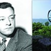
Barr Hill has been a popular hiking and picnicking spot since the 19th century, Clive said. His family has been going there since 1910, when his maternal grandparents traveled with their daughters from New Haven, Conn., to spend summers in Greensboro. Peg, Philip and their kids also summered in Greensboro. In 1938, the couple introduced the place to author Wallace Stegner and his wife, Mary, who were close family friends. The Stegners adopted it as their summer home and lived there seasonally until Stegner's death in 1993.
In 1972, Stegner won a Pulitzer Prize for Angle of Repose; in 1987 he published Crossing to Safety, a novel about Greensboro and his friendship with the Grays. In it, he wrote about Barr Hill, which he called Folsom Hill. His description is printed in the trail brochure.
The view ... is not grand in the way of western landscapes. What gives it its charm is the alternation of wild and cultivated, rough woods ending with scribed edges against smooth hayfields — this and the accent dots of white houses, red barns, and clustered cattle tiny as aphids on a leaf ... Green woods and greener meadows meet blue water, and it all looks nearly as wild as it must have looked to General Hazen's men, cutting a road to Canada through these woods during the Revolution.
Clive no longer hikes at Barr Hill. But he and his wife, Nancy Hill, love to go to the natural area, which is accessible by car up a narrow dirt road.
"I take sandwiches and sit up there," Clive said.
— S.P.
Island Oasis

Tracy Woods Community Trail, 36 Tracy Road, South Hero. The one-mile trail is easy and level.
Like generations of kids who grew up in the Champlain Islands, Naomi King spent time exploring Tracy Woods, a 35-acre forest off Route 2 in South Hero. Charles Tracy, the forester whose family has owned the land since 1841, regularly took local schoolchildren and scout troops on nature hikes along the trails he had cut. Along the way, he identified trees and wildflowers and pointed out wildlife not found in most other areas of Grand Isle County.
"Everybody in town remembers walking and camping as kids here," said King, now 54. "So it's got all these happy memories associated with it."
Eventually, King married the forester's son, Hobart Tracy. The couple still live on that property, where they raise chickens and sheep — "fat pets," she joked — and King runs Lemon Lily Farm, a small business that sells perennials.
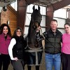
But managing both a farm and a forest is hard work. So in 2016, King, Tracy and his daughter, Anne, partnered with the South Hero Land Trust and the Lake Champlain Land Trust to preserve and manage a portion of their land as a community resource for future generations.

The newly named Tracy Woods, free and open to all, consists of 35 acres of managed woodland, seven acres of active farmland and 450 feet of Lake Champlain shoreline.
With funding from the Vermont Housing & Conservation Board, the land trusts built an eight-car parking lot and erected an informational kiosk at the trailhead on Tracy Road. The trail begins near a small round barn that, according to King, Tracy's father built in the early 1960s using cedar posts he cut from the forest and plans he mail-ordered from Yankee magazine.
On a recent visit, Chris Boget, executive director of the Lake Champlain Land Trust, and Matt Fidler, the organization's restoration and stewardship coordinator, were walking the trails to remove invasive garlic mustard.
Fidler generously provided insect repellent, which was essential that afternoon; Tracy Woods has a swamp that gets buggy this time of year.
From a mowed path along the southern edge of a field, the trail becomes a well-worn path in the woods, which include a healthy mix of new and old growth: cottonwood, hickory, sugar maple, ash, paper birch, and 100- to 250-year-old oak.
"It'd take two of us to hug that tree," Boget remarked, pointing to a gnarled oak.

Hikers walking at a brisk pace can complete the looped trail in half an hour or less; a short spur offers views of Mount Mansfield and Camel's Hump on clear days. But by racing through the woods, you're likely to miss many of its more subtle natural features. In early spring, hikers can spot wildflowers, such as bloodroot, jack-in-the-pulpit and trillium.
There's also plenty of wildlife. Within minutes, I spotted two pileated woodpeckers, a turkey vulture and a great blue heron. Tracy Woods is also home to coyotes, mink, foxes, deer, skunks, owls and bobcats.
"Wildlife just respond to areas like this," Boget said. "If you just take a moment, you can see the dragonflies and butterflies being a bit more abundant than when you're in your own backyard. They've been here forever, and, luckily, we're saving it."
The trails are open year-round, from dawn until dusk, for walking, running, snowshoeing and skiing; cycling and motorized vehicles are prohibited. Dogs are permitted but must be leashed to prevent them from harassing livestock and wildlife.
— K.P.
Forever Glades

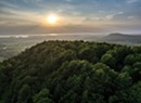
Braintree Mountain Forest, Riford Brook Road, Braintree. There are 15 miles of strenuous trails with occasional steep climbs.
It seemed almost a shame to visit the Braintree Mountain Forest for the first time in warm weather. Almost. The forest is beautiful at any time of year. But in winter the views from the stunning ridgeline, visible from the west side of Exit 4, are wide open in all directions and, as many locals have discovered, the backcountry glades are deep in snow.
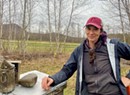
How good are those glades for skiing? Paul Kendall, who, along with his wife, Sharon Rives, donated this 1,547-acre tract of woodlands to the New England Forestry Foundation in 2013, called the 1,000-foot elevation drop "a black-diamond dive, with trees in the way."
That was abundantly clear as I climbed a steep trail from the Braintree home of Kendall and Rives to the top of 2,525-foot Thunder Mountain. Though some park their cars on Kendall Road and hike across the couple's fields, there are two public trailheads along Riford Brook Road, which are maintained by volunteers from the nonprofit Ridgeline Outdoor Collective. Both display maps of the area.
Those trails lead to four other peaks within Braintree Mountain Forest: Round Top (2,778), Twin Peaks (2,896), Skidoo Peak (2,901) and Braintree Mountain (3,030). In essence, the forest is a large basin that serves as the headwaters for Riford Brook.
Two things are immediately evident on Thunder Mountain. First, the limited switchbacks and steep ascent reveal that this trail was initially made for logging — not hiking.
Second, based on the ample vegetation on the trail itself, the mountain receives far less foot traffic than comparable peaks in Vermont. It's a pleasant surprise to discover moss-covered rocks and untrammeled pine cones at the summit. I didn't see another soul.

A New York native, Kendall first began coming to Braintree after his parents purchased a rundown sheep farm in 1951 that later became the family's summer camp. But it was no lazy vacation getaway, Kendall noted. As one of five kids, he spent 10 weeks each summer with his family fixing up the house and surrounding property. Kendall's parents named the place Todhah Hill, from the Hebrew word for thanksgiving.
In the 1970s, Kendall began acquiring adjoining parcels of forestland around the farm. Eventually, he and Rives formed the Todhah Hill Foundation to preserve access to their land, which locals had used for decades for hunting, skiing, hiking and snowshoeing.
In 2013, Kendall and Rives, who ran the foundation together, transferred its ownership to the New England Forestry Foundation. They chose the foundation, Kendall explained, because of its commitment to maintaining the land as a working forest, with occasional timber harvests.
The forest remains largely undeveloped, but Kendall noted that there are hints of past inhabitants, including the occasional cellar hole. About halfway up Skidoo Peak, hikers come upon the Bell Gates Cabin. Available for day use only, it serves as a warming hut for glade and cross-country skiers.
Thunder Mountain is about a two-hour round-trip hike; getting to the ridgeline on the Twin Peaks Trail can take half a day or more. According to Kendall, many people enjoy hiking to the top of Braintree Mountain — also called "30-30" for its 3,030-foot elevation — for the summit views. He estimated that it's a four-hour trip "depending on how fast you go and whether you get lost."
In Kendall's experience, visitors are generally respectful of the land and appreciative of its owners. Though bicycles, ATVs and other motorized vehicles are not permitted in the forest, in winter the Vermont Association of Snow Travelers maintains a trail that passes through the property.
"They park along the road and wave to us as they go up through the woods," Kendall said. "Every year there's going to be some jerk, OK? But we're not gonna close the trail because of one jerk."
In fact, Kendall emphasized that his experience with the public has been overwhelmingly positive. Meeting other people who appreciate the land the way he and Rives do, he said, is "a real joy. People just love it."
— K.P.
'Round Town

The Trail Around Middlebury. A 19-mile network of easy and moderate trails. 802-388-1007.
Who imagined a 21st-century Vermont town could be circumnavigated by a footpath so well designed that it's mud-free in June? Founded in 1987, the nonprofit Middlebury Area Land Trust worked for decades to build the 19-mile Trail Around Middlebury, parcel by parcel, connecting conserved private property, town parks and acreage owned by Middlebury College with three pedestrian bridges over the Otter Creek. The loop, aka the TAM, which locals regularly walk, run, cross-country ski and bike, is a compelling case for land protection and stewardship through municipal public recreation.
During the pandemic, traffic doubled, according to lead trail volunteer John Derick, whose talents range from hands-on engineering to organizing work crews. He also does landowner relations. "If they've got a problem, they call me," he said with a laugh.
I had consulted the organization's interactive online trail maps to plan my shortened, sample route, which would take me from Weybridge's Route 23 through the Otter Creek Gorge Preserve and Wright Park into Middlebury from the north. While the combined mileage of each distinct stretch wasn't easy to calculate, I could see that paved roads intersected the nature trail frequently enough that I could bail if I had to — one of several benefits of urban hiking.
I easily spotted the parking area off Weybridge Road and the info kiosk that marks the start of the Jackson Trail — one of a dozen trailheads that designate distinct sections of the TAM. I locked my car and headed north on a short stretch of boardwalk into a forest that climbed gently above the wetland below.

Despite some very motivated mosquitoes, I immediately noticed how the path through the woods twisted and turned — over pine needles, wood chips, and occasional gravel — in ways that enhanced the natural area's beauty. In addition, the ups and downs were easy on the knees, and, miraculously, the trail was mostly dry. It stayed that way, and so did my feet, for the next six miles.
I soon discovered another benefit of being close to civilization: frequent scenery changes. After the first half hour in the forest, the trail opened up into a grassy field through which a six-foot-wide path had been mowed. I walked in the sunshine amongst red-winged blackbirds until I got to Hamilton Road. The trail continued past a building owned by Monument Farms Dairy — there were two trucks along the side — and another hayfield, this one neatly trimmed. I followed the siren song of a bullfrog north to a pond that was busy with birds.
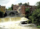
Guided by eye-catching signage, I walked for about three hours total, up and down a ladder, past wild iris, across a bridge suspended over roaring Belden Falls to the eastern side of Otter Creek. Never did I wish that a particular section would come to an end. My only regret was that I couldn't do the whole 19-mile trek, which includes views from Chipman Hill, the site of Middlebury's Snow Bowl precursor; and the cross-country ski trail through the college's golf course.
After walking through Wright Park, I arrived at the official entrance and picked up a proper paper map. The trail turned into the paved Seymour Street Extension, and I switched from birding to people watching. The view was entirely new to me, even though I lived on that same street, closer to town, for a year when I attended Middlebury College some 40 years ago. Similarly, when the Pulp Mill Covered Bridge suddenly appeared, I barely recognized the local landmark. Although TAM signs pointed left to downtown, I asked a man wearing pink shorts for directions, just to be sure.
A hot, half-mile sidewalk stroll later, I walked into editor/publisher Angelo Lynn's office at the Addison County Independent, and we shared a great mosquito-free lunch at Costello's Market. I got a good last look at modern Middlebury — still charming with a new train tunnel now buried under its historic downtown — before he gave me a most welcome ride back to where I'd started.
— P.R.
Farm to Trail

Templeton-Fairmont Trail, trailheads on Dodge Road and Center Road, East Montpelier. A 1.5-mile easy trail with one steep section.
The springtime central Vermont sounds of birdsong, sweet and high, and tractor, low and rumbling, come together in a alfalfa field in East Montpelier. You don't need to be a farmer to experience this seasonal delight.
Walkers will hear the birds and machinery — and may also smell freshly spread manure — while ambling along the Templeton-Fairmont Trail. It's part of the 15-mile East Montpelier Trails network, which is almost entirely on private land yet open to the public for walking and some biking. (E-bikes aren't allowed.)
One end of the Templeton-Fairmont Trail starts on Dodge Road near its intersection with Partridge Run, where a small parking area and signage mark the spot. Here, the 1.5-mile trail begins with a pleasant walk on an old town road that passes through woods and leads to Fairmont Farm.
Where road meets farm field, a stone marker describes the area's history and its 1788 settlement by brothers-in-law from Peterborough, N.H. From the agricultural land, a view of mountains to the east includes Spruce Mountain in Plainfield.
The trail then turns west and follows a farm road bordering the field. No rest is necessary, but a wooden bench on a pair of logs offers a sweet spot to take in the surroundings. The path then heads into the woods, descends and crosses property owned by Templeton Farm, which also grants public access.
"We're happy to let people enjoy it," said Clara Ayer, 33, of Fairmont Farm. The multigenerational dairy farm grows crops in several towns on about 3,500 acres, some of which it rents, and milks 1,450 cows. "We use the trails, and we love them, too," Ayer said. She asks that people stay on the marked trail.

At its other end, the Templeton-Fairmont Trail meets up with the larger trail network on Center Road, where walkers can choose between two paths. One is the Ormsbee Trail, an easy one-mile loop that also edges a rolling farm field and cuts into woods. Nearby homes signal that the tranquil and scenic route traverses a town of about 2,500 people.
The nonprofit East Montpelier Trails, formed in 1993, maps, marks and manages the trails. The volunteer-run organization is currently working to add three miles of trails to its network.
"The ultimate goal is to create a circular network where you can begin and end in the same spot without retracing [your steps,]" said board member Dave Webb, an environmental engineer with the Agency of Natural Resources.
The nonprofit has a volunteer list of about 70 people, Webb said. On trail work days, anywhere from a dozen to 20 people pitch in. But the effort started with one person, Nona Estrin, and her two late dogs, Buddy and Zephyr — a pair of "Vermont yellows," as she call the rescue dogs.
About 40 years ago, Estrin, 82, a longtime East Montpelier resident, found herself putting her dogs in the car and driving to nearby towns to go for walks. There must be another way, she thought. One day she decided that she and her dogs would stick to their hometown.
"I went out the back door, walked for three days and came home through the front door," Estrin said via telephone. "I took my time, and I looked around."
Before she left on her walkabout, Estrin got permission from landowners to be on their property. That three-day hike would become the basis of today's trail network. To formalize it, Estrin and others worked with the Vermont Land Trust, philanthropists, farmers and other landowners to conserve land through easements and to ensure public access.
"I was the person who had the dream, and I talked a lot," Estrin said. "I was lucky enough to see it happen. The timing was right."
— S.P.
Under the Radar

East Mountain, Radar Road, Victory. The two-mile paved road is moderate to strenuous.
Vermont goes to great lengths to preserve historical artifacts from its involvement in the American Revolution, the War of 1812 and the Civil War. But it largely ignores the remnants of a more recent conflict: the Cold War.
That's readily apparent to anyone who's made the trip, either on foot or by vehicle, to the top of East Mountain in Victory. There, visitors find spent fireworks, empty shotgun shells and discarded beer bottles littered amid the crumbling, graffiti-tagged ruins of the East Haven Radar Base.
But the steep access road, in surprisingly good condition, winds uphill through a thick alpine forest where hikers pass streams and ponds, as well as evidence of wildlife, including bear, moose and deer. The 3,438-foot summit offers stunning views of Camel's Hump to the west and Mount Washington to the east. The mountain seems ideally suited to become another state park.
Built in the mid-1950s, the radar station was commissioned by U.S. Air Force General Curtis LeMay, considered by some to be the inspiration for the paranoid, cigar-smoking General Jack D. Ripper in Stanley Kubrick's 1964 film, Dr. Strangelove or: How I Learned to Stop Worrying and Love the Bomb.
For seven years, the East Haven Radar Base served as one of hundreds of early-warning stations across the northern U.S. Their job was to alert Strategic Air Command to incoming bombers and intercontinental ballistic missiles headed over the North Pole from the former Soviet Union.
At its peak, the East Haven facility employed about 175 military and civilian personnel, until the U.S. Air Force decommissioned it in August 1963. Its sister facility in Vermont, the golf ball-shaped radar dome, or radome, that sits atop Bellevue Hill in St. Albans, is still used by air traffic controllers at Burlington International Airport.

Mathew Rubin of Montpelier is president of Spruce Mountain Design and a developer and operator of solar and hydroelectric energy projects throughout Vermont. About two decades ago, Rubin bought 40 acres on East Mountain, intending to install wind turbines on its summit. That idea was scuttled in 2004 after the Vermont Public Service Board denied him a permit. Rubin said he has no current plan to develop the property.
"If anyone has an inspiration for what to do with it," he said, "I'm open to suggestions."
Although boulders and a large, rusty metal tank ostensibly block the trailhead, four-wheelers have carved a rutted path around them. But Rubin doesn't allow motorized vehicles, so visitors should park at the bottom and hike up.
At the base of the road are the remains of the old mess hall, motor pool and assorted other outbuildings. At the summit, the 84-foot-tall main building is surrounded by four smaller structures that once housed radomes. Rubin called it "classic Cold War architecture."
As for vandalism, he added, "There's nothing to steal. If you're up there and want to take some scrap metal, please do!"
Though Rubin said he doesn't stop people from hiking to the summit, he strongly advises that visitors not enter any of the buildings, which contain asbestos, or climb staircases or ladders, all of which are in disrepair.
In all, the abandoned base has an eerie, post-apocalyptic feel that would seem quaint were it not for the tragic events unfolding in Eastern Europe.
Getting to the trailhead for East Mountain requires several miles of driving on unpaved roads. From the NEK town of Victory, take Victory Road to Radar Road, then follow it uphill about five miles to its terminus. Don't take Radar Road from North Concord, no matter what a GPS advises. Part of that end of the road is private and posted.
— K.P.
How to Hike Respectfully on Private Land
The state of Vermont is at an "inflection point" regarding land stewardship and outdoor recreation, said Becca Washburn, director of lands administration and recreation at the Vermont Agency of Natural Resources. The moment is both a "tremendous opportunity and a challenge," she told Seven Days.
It comes as greater numbers of people are spending time outdoors – hiking, mountain biking and participating in other activities — and some are perhaps not fully aware of the "stewardship ethic, the trail ethic," Washburn said.
"If there's something that keeps me up at night, it's how to be a leader in outdoor recreation," she said, "and thinking about practicing good stewardship."
Washburn advises that people be "mindful about what it means to be on someone else's land and using it at the generosity of that landowner."
She warned that if outdoor enthusiasts fail to follow guidelines or practice sound stewardship, they risk losing the opportunity to recreate on private property. A hiker and mountain biker, Washburn provided the following guidance for recreating on other people's property.
Stay off closed trails during mud season. Consider volunteering with your local trail organization to help with maintenance.
Leave no trace. Take all your garbage with you. Don't damage trees or remove anything, such as rocks. Respect wildlife and other users.
Stay on marked trails. By staying on the trail, you keep your impact minimal. You also show respect for landowners, who often use their property for multiple purposes.
Respect each other and build an inclusive outdoors. We all love to play outdoors. Make sure everyone's experience is enjoyable and do your part to ensure that the land is available for the next visitor. Keep pets under control. Be an active part of making the outdoors welcoming and inclusive for all abilities and identities.
Show appreciation for landowners. Trails rely on the generosity and care of public and private landowners. Respect signage and be aware of your surroundings. Trailheads are often busy places located in communities where people live. Drive slowly and don't block driveways or roadways.
The original print version of this article was headlined "Promised Lands"
About The Authors

Ken Picard
Bio:
Ken Picard has been a Seven Days staff writer since 2002. He has won numerous awards for his work, including the Vermont Press Association's 2005 Mavis Doyle award, a general excellence prize for reporters.
Ken Picard has been a Seven Days staff writer since 2002. He has won numerous awards for his work, including the Vermont Press Association's 2005 Mavis Doyle award, a general excellence prize for reporters.

Sally Pollak
Bio:
Sally Pollak is a staff writer at Seven Days. Her first newspaper job was compiling horse racing results at the Philadelphia Inquirer.
Sally Pollak is a staff writer at Seven Days. Her first newspaper job was compiling horse racing results at the Philadelphia Inquirer.

Paula Routly
Bio:
Paula Routly came to Vermont to attend Middlebury College. After graduation, she stayed and worked as a dance critic, arts writer, news reporter and editor before she started Seven Days newspaper with Pamela Polston in 1995. Routly covered arts news, then food, and, starting in 2008, focused her editorial energies on building the news side of the operation, for which she is a regular weekly editor. She conceptualized and managed the “Give and Take” special report on Vermont’s nonprofit sector, the “Our Towns” special issue and the yearlong “Hooked” series exploring Vermont’s opioid crisis. When she’s not editing stories, Routly runs the business side of Seven Days — overseeing finances, management and product development. She spearheaded the creation of the newspaper’s numerous ancillary publications and events such as Restaurant Week and the Vermont Tech Jam. In 2015, she was inducted into the New England Newspaper Hall of Fame.
Paula Routly came to Vermont to attend Middlebury College. After graduation, she stayed and worked as a dance critic, arts writer, news reporter and editor before she started Seven Days newspaper with Pamela Polston in 1995. Routly covered arts news, then food, and, starting in 2008, focused her editorial energies on building the news side of the operation, for which she is a regular weekly editor. She conceptualized and managed the “Give and Take” special report on Vermont’s nonprofit sector, the “Our Towns” special issue and the yearlong “Hooked” series exploring Vermont’s opioid crisis. When she’s not editing stories, Routly runs the business side of Seven Days — overseeing finances, management and product development. She spearheaded the creation of the newspaper’s numerous ancillary publications and events such as Restaurant Week and the Vermont Tech Jam. In 2015, she was inducted into the New England Newspaper Hall of Fame.


Latest in Category


Speaking of...
-

Dog Hiking Challenge Pushes Humans to Explore Vermont With Their Pups
Apr 24, 2024 -
Totality Towns: What to Do and See in the Path of the Eclipse
Apr 2, 2024 -
Popular Hiking Trails Will Be Closed for Mud Season During the Eclipse
Mar 22, 2024 -
Middlebury: What to See, Do and Eat During the Eclipse
Mar 6, 2024 -

A Vermont Teacher Through-Hikes the 115 Tallest Peaks in the Northeast
Sep 6, 2023 - More »

find, follow, fan us: