Switch to the mobile version of this page.
Vermont's Independent Voice
- News
- Arts+Culture
- Home+Design
- Food
- Cannabis
- Music
- On Screen
- Events
- Jobs
- Obituaries
- Classifieds
- Personals
Browse News
Departments
Browse Arts + Culture
View All
local resources
Browse Food + Drink
View All
Browse Cannabis
View All
-
Culture

'Cannasations' Podcaster Kris Brown Aims to 'Humanize'…
-
True 802

A Burlington Cannabis Shop Plans to Host…
-
Business

Judge Tosses Burlington Cannabiz Owner's Lawsuit
-
Health + Fitness

Vermont's Cannabis Nurse Hotline Answers Health Questions…
-
Business

Waterbury Couple Buy Rare Vermont Cannabis License
Browse Music
View All
Browse On Screen
Browse Events
Browse Classifieds
Browse Personals
-

If you're looking for "I Spys," dating or LTRs, this is your scene.
View Profiles
Special Reports
Pubs+More
Dam Scary: Intense Storms Push Vermont’s Aging Structures to the Brink
Published July 26, 2023 at 10:00 a.m. | Updated August 2, 2023 at 9:59 a.m.
In Cabot, the old Clark Sawmill Dam collapsed under the force of the raging Winooski River, just as safety experts had long warned it would.
In Calais, locals armed with tarps and cinder blocks banded together in a bucket brigade, a desperate but ultimately successful push to prevent the 123-year-old Curtis Pond Dam from failing.
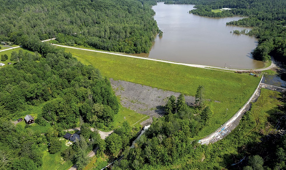
In Montpelier, floodwaters rose behind the 115-foot-high Wrightsville Dam to within inches of the spillway, for the first time since the dam was constructed in 1935. Anxious downstream residents scrambled for higher ground.
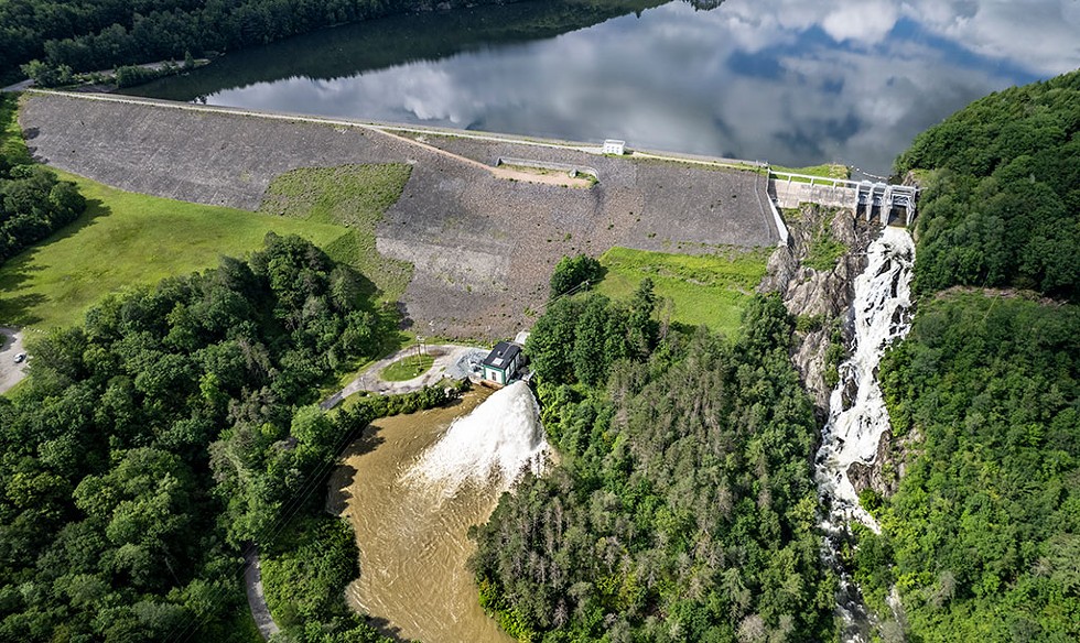
And at the Waterbury Reservoir, engineers were forced to release water from the largest state-managed dam while facing obstacles that included a malfunctioning water-level sensor, floodgates that need replacement and a badly eroded spillway. A $60 million fix is in the works, but it will be years before the repairs are designed, let alone funded and built.
A full assessment of the damage to all dams in the state is under way. Inspectors have so far found more than two dozen high or significant hazard dams with "defects" likely caused by the floods that will have to be repaired. Experts say it's clear that more frequent, more intense rainstorms are pushing dams toward their breaking points.
The Condition of Vermont Dams
To zoom in on your area, pinch or scroll on the map. Hover over or tap a dot to see the report for each dam.
Map created by Sophia Hodson
This data is from the U.S. Army Corps of Engineers’ National Inventory of Dams.
Vermont has its own dam inventory, which includes some smaller dams not included in the federal data.
Find the state's database here.
According to federal data, 63 Vermont dams are in poor condition and are also listed as posing high or significant hazards, meaning their failure would likely threaten lives or property. (The federal database does not include every dam in the state, including some that are regulated separately by the Vermont Public Utility Commission.)
Waterbury is the largest dam in the state's inventory with a "high hazard" rating and in poor condition. Others include the 25-foot-high Institute Pond Dam, built in 1911 across the Passumpsic River in Lyndon; and the Stiles Pond Dam that provides water to St. Johnsbury.
Dozens of other dams listed in poor condition — including those at Springfield Reservoir, Wright Reservoir in Hartford, Norton Brook Reservoir in Bristol and Blodgett Reservoir in Bradford — have a slightly better rating as "significant" hazards.
In 2018, Vermont strengthened its dam-safety law, but the state's dam inspectors are still drafting new rules to address deteriorating structures. Fixing just the most hazardous dams could cost $230 million, according to a recent estimate by the Association of State Dam Safety Officials.
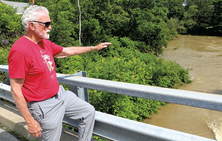
The state has earned praise for its flood-protection work in the 12 years since the disastrous floods caused by Tropical Storm Irene, but July's intense rains underscored just how vulnerable many riverside communities remain. That fact isn't lost on Steve Gold. He's not a dam expert, but he has lived downstream from the Wrightsville Dam since 1975 and feared for his home during the July flood.
"The state has to take a serious look at flood control in the whole Winooski basin based on this experience," he said. "Clearly, what we have in place now is not adequate."
Building additional, costly flood-control dams is generally not seen as a practical solution. But modifying existing dams or managing them differently — such as by lowering water levels behind them before storms so they can capture more runoff — are strategies used elsewhere that Vermont could embrace.
Removing more so-called "deadbeat dams," derelict structures that can worsen flooding, is increasingly viewed as an approach the state will need to accelerate to adapt to a changing planet.
Vermont has made good but limited progress toward this goal and now needs to redouble those efforts, said Mike Kline, a private consultant who once managed the rivers program at the Department of Environmental Conservation.
"We can't dig our way out of 200 years of river manipulation in a mere five or 10 years," Kline said. "This flood has once again shown us the problem is huge."
Big Dams, High Stakes
The Great Flood of 1927 remains the worst natural disaster in Vermont history. Following a wet October, the remnants of a November tropical storm dumped more than nine inches of rain in some places, triggering catastrophic flooding that hit hardest in the Winooski River valley, where much of the state's population lived. The rising water killed 84 people, destroyed nearly 1,300 bridges, drowned houses and wiped out farms.
In the aftermath, the federal government built three enormous flood-control dams on Winooski River tributaries in Waterbury, Middlesex and East Barre. The Civilian Conservation Corps, the Great Depression-era federal jobs program, put more than 2,000 men to work on the Waterbury Dam across the Little River. When completed in 1938, the dam stood 187 feet high and nearly 1,845 feet long and was the largest earth-filled dam east of the Mississippi.
State engineers paid particularly close attention to these dams during this month's flood. Ultimately, they worked as designed and protected communities from even greater devastation.
The Waterbury Dam "functioned beautifully over the course of this and prior flooding events," Neil Kamman, director of the Water Investment Division of the Department of Environmental Conservation, said.
The Wrightsville Dam north of Montpelier also did its job, successfully limiting floodwaters entering the North Branch and preventing even worse flooding in hard-hit Montpelier.
"That dam kept a disaster from becoming a catastrophe," said Gold, the downstream homeowner, whose personal damage was limited to a flooded basement.
During the storm, though, all eyes were anxiously watching the water level behind the Wrightsville Dam as it rose toward the top of its spillway. Montpelier city manager William Fraser warned the public at 3:53 a.m. on July 11 that the dam was running out of capacity and that an overspill "would drastically add to the existing flood damage" in the city. Residents along the North Branch "may wish to go to upper floors of their houses," he suggested.
Gold and his wife spent an anxious morning packing their car and calling friends on higher ground who could take them in if needed. In the end, it wasn't necessary. The water never made it over the graffiti-covered spillway, though it came to within 10 inches of the top.
The swollen North Branch nevertheless continued barreling toward downtown Montpelier. The tributary normally flows behind stately homes on Elm Street, through downtown and empties into the Winooski River behind Shaw's supermarket. But the Winooski itself had risen so high it couldn't absorb water from the smaller stream. Finding no outlet, the North Branch began backing up into downtown Montpelier.
Twelve miles downstream, Ben Green, the state's chief dam safety engineer, had driven up to the imposing Waterbury Dam. At 9:45 a.m. on July 10, he closed the three gates that sit atop the spillway. These devices, called tainter gates, are huge curved steel doors that, when shut, increase the capacity of the 860-acre Waterbury Reservoir.
The gates can't be operated remotely — just one of the challenges of operating the dam. Green couldn't risk leaving, as flooded roads could have prevented his return, Kamman recounted. So the engineer slept in the cramped control hut, ready to reopen the gates if the water rose so quickly that he needed to release water to relieve pressure on the dam.
One of the gates was later carefully opened for that reason, but only once water levels had fallen in the Winooski, meaning that the release would not trigger more flooding. The open gate sent a torrent of water down the spillway.
Green, who has been orchestrating the inspection of dams around the state, was unavailable for an interview, Kamman said. He called the state's dam experts "an unknown, underappreciated force of good for the state of Vermont."
While the Waterbury Dam held during the storm, it has significant structural shortcomings that limit its ability to effectively control floods. The floodgates can only hold back about 70 percent of the excess water that they were designed to handle, according to Kamman.
For one thing, the steel gates pivot on massive pins that have become difficult to operate due to friction in a joint, Green explained in a recorded presentation to the Friends of Waterbury Reservoir in 2022. The gates jammed during tests by the U.S. Army Corps of Engineers in the early 2000s, and the corps has "determined the gates can't be operated safely under a major flood event," Green told the group.
The concrete part of the dam's spillway, called the apron, has significant erosion. It is also not fully attached to the underlying bedrock. Water racing down the spillway could damage the spillway further, risking "stability issues with the overall structure," he said in the 2022 session.
Agency of Natural Resources officials refused to share the formal risk assessment of the dam, claiming that it is exempt under Vermont's public records act because it contains information about the dam's vulnerabilities that "could be exploited to cause harm to Vermonters downstream of the dam."
A flood control and hydroelectric dam in Oroville, Calif., nearly failed in 2017 after uncontrolled releases destroyed its spillways and risked undermining the dam itself. Nearly 200,000 people were evacuated downstream, and the dam ultimately needed a $1 billion repair.
Waterbury's $60 million dam rehab is not yet fully designed but will likely involve replacing the gates, anchoring the concrete to the bedrock and rebuilding a bridge that spans the whole apparatus, Green said.
The amount of water that cascaded for a week down the spillway and over bedrock to the Little River more than 100 feet below was never a safety concern, Kamman said, because the vast majority of it flowed over bedrock, not concrete.
The malfunctioning water level gauge was also not significant because there is a backup gauge, he said. Debris clogged the gauge and caused a sensor to malfunction, explained Rick Kiah, a supervisor with the U.S. Geological Survey division that monitors river and lake levels in Vermont and New Hampshire. A backup gauge kept dam operators informed until the faulty one was repaired just as the reservoir's levels began rising quickly, Kiah said.
The dam's effective functioning during the July storms is not entirely reassuring to Eric Chittenden, president of the Friends of Waterbury Reservoir. He remembers well Green's presentation to the group about the dam's problems.
"If I was living below that dam, I wouldn't feel very comfortable," he said.
In addition to structural challenges facing older flood-control dams, their operation is often restricted by competing demands for power generation, recreation and wildlife habitat, explained Francis Magilligan, a geographer at Dartmouth College who studies dams and dam removal. Flood-control dams can work well — if dam operators preserve enough capacity to absorb large inflows, he said.
But in many cases, the dams also are paired with hydroelectric facilities that require a certain volume of water be maintained in the reservoir to run effectively, he said. The Washington Electric Cooperative operates a power plant at the Wrightsville Dam, and Green Mountain Power runs one at the Waterbury Dam.
Magilligan said electricity generation can conflict with flood-prevention goals. Draining a reservoir over a spillway means a utility loses the power it might have generated from that water.
In addition, man-made water bodies such as the Waterbury Reservoir are often popular recreation destinations, their shores dotted with campgrounds, beaches and boat launches. They provide a home for fish, water birds and other wildlife.
Dam managers come under pressure to keep water levels stable enough for these uses as well, Magilligan noted, and thus face the challenge of balancing competing interests.
A River Runs Through It
click to enlarge 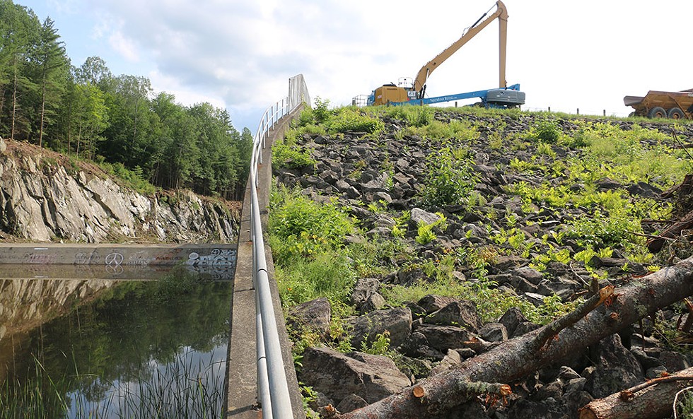

- Kevin Mccallum ©️ Seven Days
- Machinery used to clear debris at the Wrightsville Dam
From the state's earliest days, Vermonters have built their villages and towns beside rivers. River floodplains provided fertile ground for farming and flat land for buildings and roads. Settlers built dams to provide the power to run mills that cut lumber, ground grain and made products from butter boxes to wool socks. For these advantages, people were willing to pay the price of periodic floods.
Many of the towns inundated by flooding this month are particularly susceptible to that risk: According to state data, 9 percent of all buildings in Montpelier are located in flood hazard zones. So are 15 percent of the structures in Marshfield, 13 percent in Ludlow Village and 22 percent in Waterbury Village.
Today, Vermont is dotted with hundreds of old, obsolete dams that alter river flows and represent an increasing liability. Most are owned privately; the rest, by public utilities and governments.
The 1927 flood destroyed more than 60 dams. Failures have remained fairly common in the decades since, according to the Agency of Natural Resources. In the past 20 years, small dams have collapsed in Calais, Bennington, Woodbury, Williamstown, Waitsfield, Marlboro, Warren and Morristown.
The responsibility for keeping tabs on the unwieldy menagerie of river infrastructure falls largely to the five-person Dam Safety Program within the Department of Environmental Conservation. These state officials inspect dams for problems and assign them ratings based on physical condition. They also assess the danger that a dam's failure would pose to life and property — known as a dam's hazard potential. A "high hazard" dam is one that would likely kill someone if it burst.
But participating in the Dam Safety Program has long been voluntary. Owners have been able to deny access to inspectors or ignore suggested improvements. Many smaller dams weren't even recorded in the state's database.
Dams known to be in poor condition have languished on the list for as long as 18 years, a 2022 report by the State Auditor's Office found. And with a spotty and infrequent inspection regime, outdated hazard ratings likely understate the risks to downstream communities.
"It is far too often that dam safety shortcomings are left unaddressed until a major dam failure or incident serves as a difficult reminder," Peter Walke, then-commissioner of the DEC, wrote in an official response to the auditor's report. He noted that those "reminders" may be more frequent as aging infrastructure meets climate change-induced severe weather.
The American Society of Civil Engineers this year graded Vermont a C for dams in its "Report Card for Vermont's Infrastructure."
Following Irene, the Vermont legislature, under pressure from environmental groups, bolstered its dam regulation program. The 2018 law empowers the Agency of Natural Resources to make rules that require property owners to register their dams, allow regular inspections, make necessary repairs and take action during emergencies. As part of the law, the state created an online dam inventory that currently includes information about nearly 1,000 dams. The database was only made available to the public in April.
The new inspection and enforcement regimen is not yet in effect. The agency says it must write more rules before inspectors can, for instance, begin compelling dam owners to make repairs. Those rules are still being drafted and may not be adopted until at least July 2024.
A dam collapses
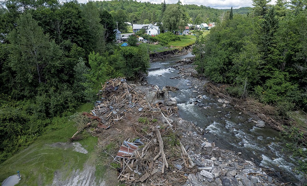
On July 10, as the Winooski River swelled from torrential rains, the Clark Sawmill Dam in Lower Cabot burst. No one was hurt, but the collapse changed the river.
"We all look like we have the Grand Canyon in our backyards," said Jennifer Miner, the town's emergency management director, who lives just upstream.
For nearly 20 years, planners and engineers had raised concerns about the poor state of the small dam that stretched 70 feet across the river and stood 14 feet tall.
There's been a dam in that spot since Moses Stone built a sawmill on the river in 1797. The sawmill later became a woolen mill, was briefly a butter box factory, and then operated again as a sawmill until about 1997. The last iteration of the stone-and-concrete dam is thought to date back to the late 19th or early 20th century.
The dam was rated a "low hazard" even though a 2006 river management plan created for the Town of Cabot concluded it had become a threat to downstream property. Ten years later, an engineering firm confirmed the privately owned dam had become a liability.
"The Clark Saw Mill Dam and old mill works are in ruins and need to be removed to improve public safety and to prevent a large, sudden release of sediment and unchecked erosion of the channel," the report stated.
Removing an old dam is complicated work, as meeting minutes from a 2022 working group demonstrate. In addition to engineering challenges, a thornier question loomed: Who pays? The town worried about costs and liability; the owner, Ed Larson, was concerned about getting paid what he thought his land was worth. Larson did not return a call for this story.
Selectboard member Mike Hogan said the dam had caused flooding in fields, including his, for years. The question of removing it had been a headache, but now, he said, "It's a moot point."
"I'm so glad, as a member of the selectboard, that I don't have to deal with it now," he said.
Michele Braun, executive director of the Friends of the Winooski River and a member of the Clark Sawmill Dam working group, has helped get similar dams dismantled. One recent project, in Northfield, required removal of enough sediment from behind the dam to fill 1,500 dump trucks. A dozen or so organizations chipped in to pay for the more than $400,000 job.
Braun lamented the effects of an uncontrolled collapse of the Clark Sawmill Dam.
"It will result in a much deeper stream channel, which means that stream is less connected to its floodplains," she said. Unable to spread out onto the floodplain during future rainstorms, water will travel down that stretch of river faster and with more power — fueling new flood problems downstream.
The public can understand removing a dam for such purposes as allowing fish to swim upstream to spawn. Yet it can seem counterintuitive that carefully removing old dams can improve flood control, Roy Schiff, a principal water resources engineer with SLR International, said.
Most people think of even small, decrepit dams as providing some protection against floods. In fact, the opposite is true. Such river barriers actually impede the flow of water, because they become choked with sediment that raises riverbeds — reducing flood-carrying capacity. This can cause waterways to burst their banks sooner and more forcefully than they would otherwise, he said.
Schiff is working with Karina Dailey, ecological restoration coordinator with the Vermont Natural Resources Council on a dam removal project in Shrewsbury. The work, which is still under way, likely prevented the dam's collapse during the flood and saved a nearby road from being blasted with a sediment plume that could have destroyed it, he said.
"These old dams are kind of like hidden beasts out there," he said.
The problem is particularly pronounced around Montpelier, where the Winooski is hemmed in by a "human-created canyon," Kline, the river management consultant, said. During most rainstorms, the channel system swiftly moves water westward toward areas where it can slow down and spread out. But during major floods, anything that impedes that flow becomes an acute problem for the Capital City, he said. For this reason, the state is studying the removal of three old dams along the Winooski in the city.
"I think all sorts of benefits would come from removing those dams, and I've got my fingers crossed that one of them is flood resilience," Kline said.
Rallying the Troops
click to enlarge 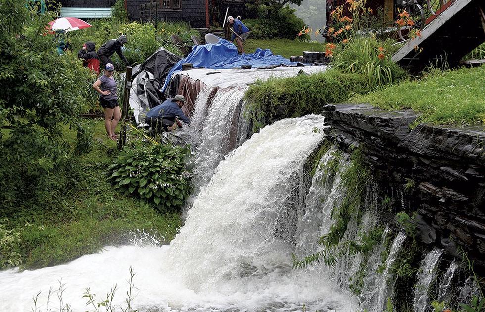

- Jeb Wallace-Brodeur
- Community members using tarps to save the Curtis Pond Dam during this month's flooding
Curtis Pond is one of many things that make the village of Maple Corner appealing. But it is not a natural body of water. For more than 18 years, state engineers have classified the dam that holds it as a "significant hazard." Experts who assessed the structure in 2019 warned that a single big storm could cause catastrophic failure and send the 76-acre pond gushing into Pekin Brook.
As rain poured down earlier this month, neighbors secured tarps around the wall of the dam with cinder blocks to prevent water from eroding the earthen mound. Others went door-to-door below the dam, warning eight households that it was time to evacuate.
While the dam is technically owned by a local couple, the community around the pond has adopted it as its own.
Over the past decade, residents have raised money to repair the dam, generating about $250,000 through concerts and pontoon boat rides. Last Town Meeting Day, voters in Calais, the town in which Maple Corner is located, approved a $450,000 bond to help fund repairs. The Calais Selectboard agreed to spend an additional $100,000 in American Rescue Plan Act funds. The project is still awaiting approval.
As water began spilling over the dam during the recent flood, it started to erode the gravel and crushed stone holding the structure together. Green, the dam safety engineer, advised residents that tarps would reduce the erosion.
Jamie Moorby, a selectboard member, had an additional strategy. She arranged for a large pump with a 7,000 gallons-per-minute capacity to be brought in from Barre. When the pump ran low on diesel, neighbors poured five-gallon containers of fuel into the machine. The device pumped millions of gallons of water from the pond into Pekin Brook, relieving pressure on the dam.
"I don't know if the dam would've survived" without the community's emergency work, said John Rosenblum, president of Maple Corner Community Store. "Everything that we needed, from tarps to blocks to diesel fuel sort of materialized ... Maple Corner is a place where that can happen."
Nick Emlen, Calais' emergency management director, hopes the cost of the pump will be covered with relief funds from the Federal Emergency Management Agency. A contractor got to work last week making urgent temporary repairs to the dam until the permanent fix can be engineered next year, he said.
Emlen said the experience made him appreciate the skill and hard work of those who built the dam more than a century ago but also drove home what it's going to take to save Vermont's dams.
"We have to face the reality of the kind of work that's going to be needed to make most of these very old dams safe in the future," Emlen said. "It's hard to even imagine the cost of something like that. It's mind-boggling."
Correction, August 23, 2023: The 55-foot-tall Ascutney Mill Dam was rated in fair condition after its most recent inspection. This story previously contained erroneous information that has been removed.The original print version of this article was headlined "Dam Scary | Intense storms push Vermont's aging structures to the brink"
Got something to say?
Send a letter to the editor
and we'll publish your feedback in print!
Tags: Environment, Seven Days Aloud, Seven Days Aloud, Seven Days Aloud, Seven Days Aloud, Seven Days Aloud, Seven Days Aloud, Seven Days Aloud, Seven Days Aloud, Seven Days Aloud, Seven Days Aloud, Seven Days Aloud, Seven Days Aloud, 2023 Flood, dams, Clark Sawmill Dam, Curtis Pond Dam, Wrightsville Dam, Waterbury Reservoir, Springfield Reservoir, Wright Reservoir, Norton Brook Reservoir, Blodgett Reservoir, Seven Days Aloud, Video
About The Authors

Derek Brouwer
Bio:
Derek Brouwer is a news reporter at Seven Days, focusing on law enforcement and courts. He previously worked at the Missoula Independent, a Montana alt-weekly.
Derek Brouwer is a news reporter at Seven Days, focusing on law enforcement and courts. He previously worked at the Missoula Independent, a Montana alt-weekly.

Kevin McCallum
Bio:
Kevin McCallum is a political reporter at Seven Days, covering the Statehouse and state government. He previously was a reporter at The Press Democrat in Santa Rosa, Calif.
Kevin McCallum is a political reporter at Seven Days, covering the Statehouse and state government. He previously was a reporter at The Press Democrat in Santa Rosa, Calif.
Latest in Environment
Speaking of...
-

Waterbury: What to See, Do and Eat During the Eclipse
Mar 6, 2024 -

After 15 Years and Two Major Floods, Montpelier’s Three Penny Taproom Is Thriving
Jan 30, 2024 -

A Donation to Montpelier's Public Library Repays a Favor From 95 Years Before
Jan 24, 2024 -

Vermont Lawmakers Are Focused on Disaster Response, but Covering the Costs May Be Tough
Jan 10, 2024 -

Backstory: July Flood Hit 'Closest to Home' for Barre-Raised Reporter Courtney Lamdin
Dec 27, 2023 - More »





find, follow, fan us: