Vermont's Independent Voice
Browse News


Browse Arts + Culture


Browse Food + Drink


Browse Cannabis


Browse Music


Browse On Screen


Browse Events


Browse Classifieds
Browse Personals

Published October 25, 2023 at 10:00 a.m.
When the Winooski River rampaged through Montpelier in July, a dam originally built to control its floodwaters was nowhere in sight. The Bailey Dam, a prominent structure spanning the river just west of the Main Street bridge, was submerged beneath the roiling, muddy waters.
But the 10-foot-high, 142-foot-long slab of concrete on the riverbed nevertheless had an impact on the downtown flooding: It likely made it worse.
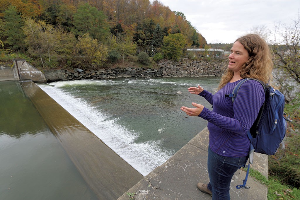
The barrier and tons of silt behind it significantly reduced the Winooski's ability to carry floodwaters away when it mattered most, said Kassia Randzio, the development and operations director for the Vermont River Conservancy.
"This dam is not holding back water. It's holding back dirt," Randzio said last week as she gazed down at the structure from the Shaw's grocery parking lot in the city's downtown.
Randzio and her Montpelier-based nonprofit have long hoped to take out the Bailey Dam and three others in and around the capital to restore the Winooski and its tributaries to something closer to their natural state. That would foster a cleaner, healthier ecosystem for fish and wildlife and new recreational opportunities such as boating.
The July flood underscored another crucial benefit to removing derelict dams: Taking them out can actually prevent or minimize future flooding, she said.
"For better or worse, these types of events illustrate the need for this work," Randzio said.
Dam removals have been on the city's radar for several years but are getting an urgent new look since the July flood caused hundreds of millions of dollars in damage to the city.
The subject came up during a council debate earlier this month over funding for a long-planned park at the confluence of the Winooski and its flood-prone tributary, the North Branch. The newly formed Montpelier Commission for Recovery and Resilience is likely to explore it in detail.
The Vermont River Conservancy has hired an engineering firm to study removing four dams around Montpelier. Mayor Jack McCullough said he's eager to read the report.
"It makes total sense to me that if we remove these impediments to the free flow of water, that the water isn't going to be hanging around right in the center of the city," McCullough said.
City Councilor Dona Bate said removing dams to reduce flooding can seem counterintuitive. That's because when people think of dams, they envision the large flood-control structures such as those in Wrightsville, Waterbury and East Barre, built with the help of the federal government after the Great Flood of 1927.
Flood-control dams have space behind them for runoff from storms to be stored, or impounded, instead of rushing downstream. Some, such as Waterbury's, have massive metal gates that operators can control; others, such as Wrightsville's, offer passive protection.
Those imposing structures are widely acknowledged to have functioned well and prevented even worse flooding in July. The four dams the Vermont River Conservancy identified for removal, on the other hand, are known as run-of-river dams, and water flows freely over them.
"These are not dam dams," Bate said. "These are nonfunctioning dams."
It's too soon to say how much the removal projects might cost, but it's a weight on local officials' minds. The city is under significant financial pressure to help residents and businesses recover from the flood, making funding such projects an obstacle, Bate said.
But as the city rebuilds, it also needs to look toward better protecting itself against future floods, and removing the dams could be a key part of that strategy. The topic is expected to get attention at the Statehouse next year, when the legislature is expected to consider establishing a state fund to help municipalities rebuild with climate change resilience in mind.
"Everything I've heard to date tells me that dam removals are essential for flood mitigation," Bate said. "I feel we have to move in that direction, and we need state and federal support to do it."
Not everyone agrees. Thomas McArdle, retired Montpelier director of public works, said the volume of water coursing through the city made the impact of the Bailey Dam "negligible."
"I really doubt it would have any impact on riverine flooding," he said.
And Thomas Weiss, a licensed hydrologist who lives in Montpelier, also said he doubts the Bailey Dam worsened the downtown flooding much.
To bring clarity to the debate, the Vermont River Conservancy recently selected SLR International of Waterbury to conduct detailed studies of the four dams. The work is funded by a $300,000 grant from the Lake Champlain Basin Program.
Roy Schiff, an engineer at SLR, said there is little question that removing dams that aren't providing flood control helps expand a waterway's capacity to carry away floodwaters.
How much is extremely site specific and will require detailed modeling. That work is getting under way soon, but evidence Schiff has seen so far, including photos and sediment left behind, shows the Winooski jumped its banks upstream of the Bailey Dam and coursed into downtown, where it joined the overflowing North Branch.
Removing a 10-foot-high dam won't necessarily create 10 more feet of carrying capacity in the river, but he's confident that models will show less flood damage from a Winooski River without the four dams.
"It's a picture and a hydrological model of the river, and you can't refute that," Schiff said.

A dam has existed at the site where the Bailey Dam now stands since at least 1821, according to a woodblock print of Montpelier in the Vermont Historical Society's collection. After the Great Flood of 1927, the Civilian Conservation Corps rebuilt the dam as a flood-control project, complete with movable gates. Those were removed in 1975.
Another of the dams is a smaller structure on the North Branch just upstream of the confluence with the Winooski and below a trestle bridge now used as a walking path. It's known as the "rat dam" and was built when sewer pipes discharged directly into the tributary. This provided rats a convenient avenue to enter buildings. The dam created a pond that submerged the sewer pipe openings, preventing rats from entering the pipes, Randzio said.
The sewer pipes are long since gone from the North Branch, but the crude dam, a barrier three to five feet high, remains. It poses a problem because it's in the heart of downtown on a waterway responsible for much of the flooding, she said. When the Winooski was at flood stage, the North Branch had nowhere to go except up, jumping its stone banks and pouring into the basements and first floors of much of downtown. Removing even this modest structure could go a long way, Randzio added.
Karina Dailey, the restoration ecologist at the Vermont Natural Resources Council, agrees. She is the head of the state's Dam Removal Task Force, which tries to identify and prioritize projects.
"Certainly, I think it would make a significant difference," Dailey said of removing Bailey and the "rat dam."
Two other dams eyed for removal are farther upstream. The Pioneer Street Dam, about 1.3 miles from downtown, is the oldest of the four, dating back to the 19th century. There is concern that sediment behind the crumbling 168-foot long, eight-foot-high dam could be contaminated because of its proximity to a former manufactured gas plant. Capital City Gas burned coal on the site to create gas from 1902 until 1949 and left behind significant coal tar contamination on the property. It was later cleaned up, and the site now houses a portable toilet storage facility.

The other is 2.75 miles farther upriver in East Montpelier and is called the Hidden Dam. Built in 1906, it's at the site of a hydroelectric facility that was destroyed in the 1927 flood. Because of the 10-foot-high dam's location in an agricultural area, the sediment trapped behind it may contain significant phosphorus.
Julie Moore, the secretary of the Agency of Natural Resources, said the state supports targeted dam removals. But that's only one of several strategies it is pursuing to improve flood resiliency. These include helping communities build back with future flooding in mind, such as moving utilities out of basements and hardening infrastructure to allow communities to better withstand and recover from floods.
Reconnecting floodplains to give rivers room to spread out is another key strategy that has worked elsewhere and needs to be closely examined throughout the Winooski basin. One such project on a former lumberyard in Brattleboro got under way this summer and is expected to reduce the flood levels on Whetstone Brook by four feet, Moore said.
The state is considering a similar project at the Agency of Transportation's central garage and training center in Berlin. The eight-acre property on the banks of the Stevens Branch flooded for the third time in 12 years in July. The state is considering relocating the garage and allowing the land to be restored to its natural state. If combined with property on the opposite side of the creek where the Berlin Mobile Home Park flooded, a substantial area could be created to allow floodwater to spread out and slow down before it enters the Winooski, she said.
Moore sent a letter to U.S. Sen. Bernie Sanders (I-Vt.) earlier this month, explaining that the state needs to do more to protect the infrastructure and communities in the Winooski River watershed but can't do it alone. She asked for $3 million and the help of the U.S. Army Corps of Engineers in conducting such a study.
"Funding for permanent flood protections is critical in order to keep residents and property safe and out of harm's way, protect infrastructure investments like dam structures and buildings, and reduce harm to the environment," she wrote.
Moore said dam removals and land acquisition for floodplain reconnection are often time-consuming because they require a "willing buyer and a willing seller."
She said, "There is no bang! And you're flood-proof."
The original print version of this article was headlined "Capital Investment | Would removing four old dams make Montpelier more flood resilient?"

Related Stories


More By This Author


About The Author

Kevin McCallum
Bio:
Kevin McCallum is a political reporter at Seven Days, covering the Statehouse and state government. He previously was a reporter at The Press Democrat in Santa Rosa, Calif.
Kevin McCallum is a political reporter at Seven Days, covering the Statehouse and state government. He previously was a reporter at The Press Democrat in Santa Rosa, Calif.
Speaking of...
-

A Group of Montpelier Residents Spruces Up the City, One Cigarette Butt at a Time
May 8, 2024 -

In Montpelier, Enna to Serve Gelato; Dairy Creme for Sale
Apr 30, 2024 -

Q&A: Downtown Montpelier Transforms Into PoemCity Every April
Apr 24, 2024 -

Video: Visiting the Kellogg-Hubbard Library’s PoemCity in Montpelier During the Month of April
Apr 18, 2024 -

Ondis Serves Seasonal Fare With a Side of Community in Montpelier
Apr 16, 2024 - More »
Comments
Comments are closed.
From 2014-2020, Seven Days allowed readers to comment on all stories posted on our website. While we've appreciated the suggestions and insights, right now Seven Days is prioritizing our core mission — producing high-quality, responsible local journalism — over moderating online debates between readers.
To criticize, correct or praise our reporting, please send us a letter to the editor or send us a tip. We’ll check it out and report the results.
Online comments may return when we have better tech tools for managing them. Thanks for reading.